Aircraft range map and how it works
An aircraft range map is a visual representation used to illustrate the maximum distance an aircraft can travel without the need for refueling. This tool is crucial for both aviation professionals and enthusiasts, offering insights into the operational capabilities of various aircraft models. Such maps are often overlaid on geographical layouts, showcasing the span of a plane's reach from a specified departure point, effectively marking the boundaries of nonstop travel potential.
The significance of aircraft range maps lies in their utility for route planning, logistics, and strategic developmental purposes. Airlines and military operations alike rely on these maps to optimize flight plans, ensuring efficiency, safety, and cost-effectiveness. Constructing an accurate range map involves considering several variables such as fuel capacity, aircraft weight, altitude, wind conditions, and air traffic restrictions. Additionally, advancements in aerodynamics and engine technologies continually alter the range capabilities of modern aircraft, necessitating regular updates to these maps.
Factors Affecting Aircraft Range
The range of an aircraft, defined as the maximum distance it can fly on a full tank of fuel, is influenced by several critical factors that play a significant role in determining its operational capabilities. One of the primary factors is the aircraft's weight, including its fuel, passengers, cargo, and any additional equipment onboard. Greater weight increases fuel consumption, thereby reducing range.
The type and efficiency of the aircraft's engines further impact fuel burn rate; modern, more fuel-efficient engines can enhance range by optimizing fuel use even during extended flights. Aerodynamic design is another important factor, as aircraft with better aerodynamic profiles experience less drag and, as a consequence, use less fuel over the same distance.
Altitude and atmospheric conditions also affect range, with higher altitudes usually offering more efficient flight conditions due to thinner air and reduced drag. However, turbulence and adverse weather conditions can force aircraft to alter their altitudes or routes, leading to increased fuel consumption. Additionally, wind patterns critically influence range; tailwinds can extend range by providing a speed boost, while headwinds have the opposite effect.
Pilot operations, such as airspeed management and flight path optimization, are essential in mitigating these variables' impact on fuel efficiency and overall range. An aircraft's range is thus a dynamic attribute shaped by a complex interplay of technical, environmental, and operational factors.
How To Interpret An Aircraft Range Map
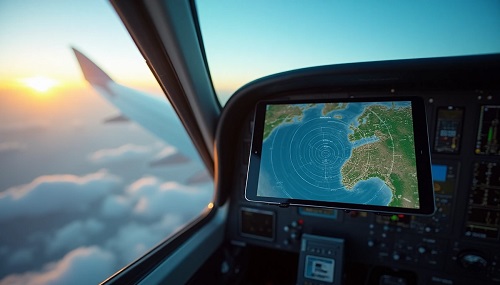
Interpreting an aircraft range map aircraft range map involves understanding the information it conveys regarding the distance an aircraft can fly under specific conditions without needing to refuel. These maps typically illustrate a series of concentric circles radiating from a central point, usually an airport or an airline's hub. The circles represent the maximum potential range of the aircraft, taking into account variables such as fuel capacity, cruising speed, and aircraft weight.
When examining a range map, it's crucial to recognize that the circles indicate theoretical maximum distances, which can be affected by real-world factors including wind conditions, air traffic control restrictions, and detours for avoiding adverse weather.
Additionally, the map might display various lines showing different range scenarios, such as with full passengers or full cargo, providing insights into how passenger weight and cargo load limit the travel distance. Such maps can also include shaded areas reflecting the aircraft's performance under different configurations or operational constraints.
Overall, while an aircraft range map provides valuable visual insight into the potential reach of an aircraft, it should be interpreted as a generalized guide, supplemented with up-to-date operational data and a consideration of the dynamic atmospheric and logistical conditions that might be encountered during flight.
Variations In Range For Different Aircraft Types
The range of an aircraft, which refers to the maximum distance it can fly without needing to refuel, varies significantly across different types of aircraft and is influenced by several factors.
Commercial airliners, for instance, are designed with a focus on long-haul capabilities, allowing them to cover thousands of miles on a single tank. Aircraft like the Boeing 787 or Airbus A350 can fly non-stop for upwards of 8,000 to 9,700 miles, facilitating transoceanic travel and connecting distant continents.
In contrast, regional jets such as the Embraer E-Jet series have modest ranges, often between 1,500 to 2,700 miles, which are optimized for shorter, regional routes.
Future Trends In Aircraft Range Mapping
As technology advances and the aviation industry pushes towards more efficient and sustainable operations, the future of aircraft range mapping is set to undergo significant changes. With the increasing adoption of digital tools and real-time data analysis, aircraft range maps are evolving from static representations to dynamic and interactive platforms.
Furthermore, the integration of artificial intelligence and machine learning algorithms into range mapping will revolutionize predictions and decision-making. These advanced systems can analyze vast amounts of historical and real-time data to suggest the most efficient routes, taking into consideration variables such as changing wind patterns and potential turbulence. With the ongoing development of electric and hybrid aircraft, range mapping techniques will also incorporate new parameters specific to these emerging aviation technologies.
As a result, range maps will become crucial tools in managing battery life and charging point navigation. Overall, the future trends in aircraft range mapping point towards a more interconnected, intelligent, and environmentally conscious aviation ecosystem, enhancing both the efficiency and sustainability of air travel.